Difference between revisions of "Atlas"
From A Wiki in the Desert
| Line 17: | Line 17: | ||
== T11 Full Map Image == | == T11 Full Map Image == | ||
| − | [[:File:AtitdFullMap.png]] (20MB) | + | [[:File:AtitdFullMap.png|T11 Egypt Map]] (20MB) |
== Faction areas == | == Faction areas == | ||
Revision as of 06:22, 20 November 2023
| Resources Legend: |  Limestone Limestone
|
 Sulphurous Water Sulphurous Water
|
 Red Sand Red Sand
|
 White Sand White Sand
|
 Tar Tar
|
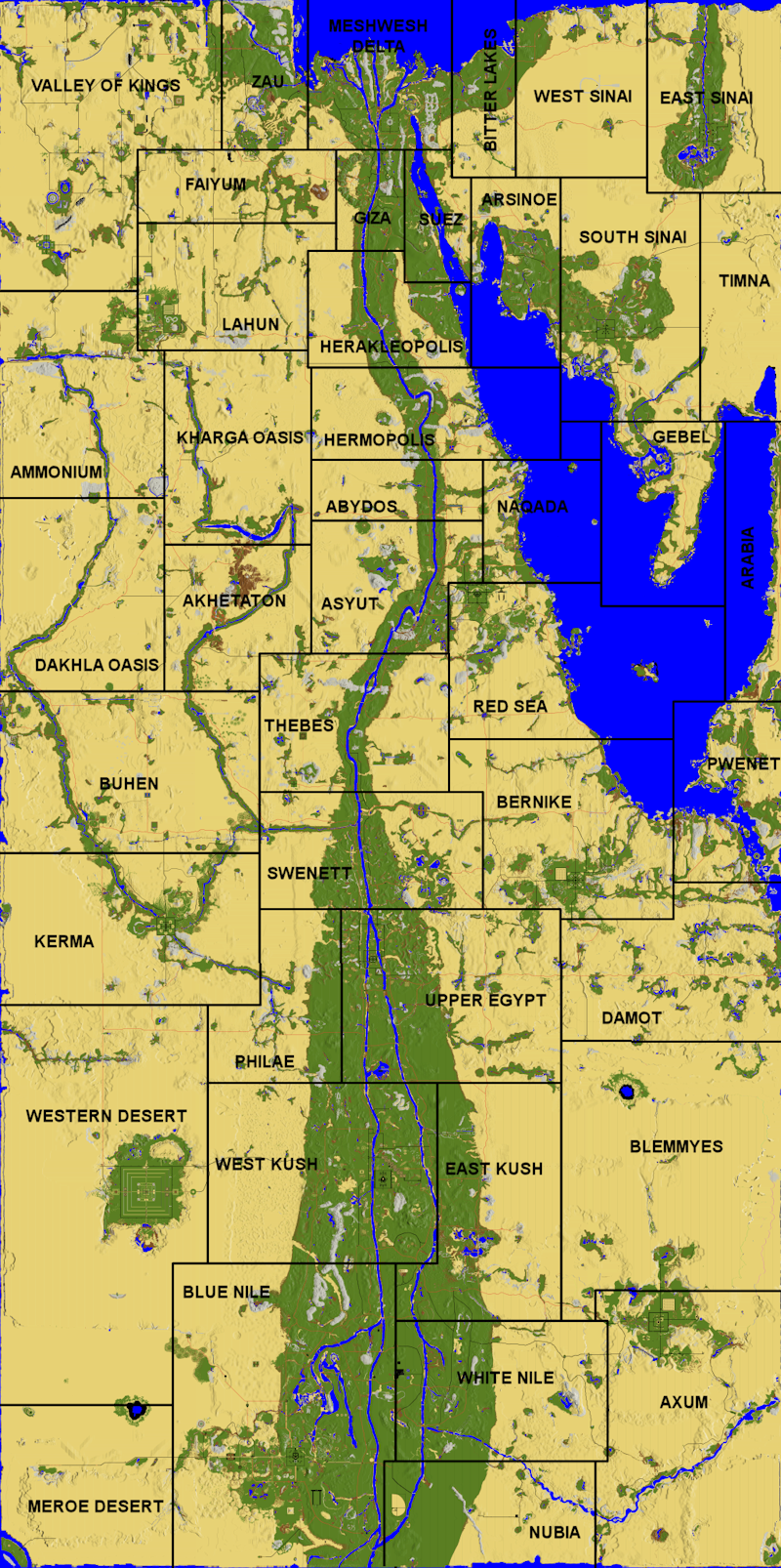
T11 Scaled Region Map
T11 Full Map Image
T11 Egypt Map (20MB)
Faction areas
- North: Meshwesh
- Mid: Hyksos
- South: Kush
Regions
- Abydos
- Akhetaton
- Ammonium
- Arabia
- Arsinoe
- Asyut
- Axum (owned by Kush)
- Bernike (owned by Hyksos)
- Bitter Lakes
- Blemmyes
- Blue Nile (owned by Kush)
- Buhen
- Dakhla Oasis
- Damot
- East Kush
- East Sinai (owned by Meshwesh)
- Faiyum
- Gebel
- Giza
- Heraklepolis
- Hermopolis
- Kerma (owned by Kush)
- Kharga Oasis
- Lahun (owned by Meshwesh)
- Meroe Desert
- Meshwesh Delta (owned by Meshwesh)
- Naqada
- Nubia
- Philae
- Pwenet
- Red Sea (owned by Hyksos)
- South Sinai (owned by Meshwesh)
- Suez
- Swenett
- Thebes
- Timna
- Upper Egypt (owned by Hyksos)
- West Kush (owned by Kush)
- West Sinai
- Western Desert
- White Nile
- Zau
Other Named Areas
- Hinterlands (beyond the edges of the map, and a bit of the Red Sea that has no land)
- Kingdom of Kush (Chariot stop in Meroe Desert)
- Kingdom of Hyksos (Chariot stop in Asyut)
- Meshwesh Tribes (Chariot stop in Meshwesh Delta)
