Difference between revisions of "Atlas"
From A Wiki in the Desert
(→Atlas) |
|||
| Line 1: | Line 1: | ||
== Atlas == | == Atlas == | ||
| − | + | * [[Atlas/Full|One Map with Everything]] | |
| − | * [[Maps| | + | * [[Maps|List of all Individual Maps]] |
| − | + | * [[Atlas/TP|Map of Tribute Posts]] | |
| Line 13: | Line 13: | ||
{{:Maps/Resources/Legend}} | {{:Maps/Resources/Legend}} | ||
| − | |||
== T9 Scaled Region Map == | == T9 Scaled Region Map == | ||
Revision as of 02:32, 29 October 2019
Atlas
This map uses the CondMap template, if this map imports data from other maps please edit those. Please see Maps for further details and links to all raw data pages
| Resources Legend: |  Limestone Limestone
|
 Sulphurous Water Sulphurous Water
|
 Red Sand Red Sand
|
 White Sand White Sand
|
 Tar Tar
|
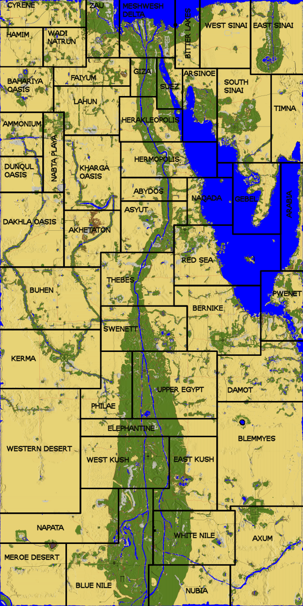
T9 Scaled Region Map
T9 Full Map Image
Faction areas
- North: Meshwesh
- Mid: Hyksos
- South: Kush
Regions
- Akhetaton
- Ammonium
- Arabia
- Arsinoe
- Asyut
- Axum (owned by Kush)
- Bahariya Oasis
- Bernike (owned by Hyksos)
- Bitter Lakes
- Blemmyes
- Blue Nile (owned by Kush)
- Buhen
- Dakhla Oasis
- Damot
- East Kush
- East Sinai (owned by Meshwesh)
- Elephantine
- Giza
- Hamim
- Heraklepolis
- Hermopolis
- Kerma (owned by Kush)
- Kharga Oasis
- Lahun (owned by Meshwesh)
- Meroe Desert
- Meshwesh Delta (owned by Meshwesh)
- Napata
- Naqada
- Nebta Playa
- Philae
- Pwenet
- Red Sea (owned by Hyksos)
- South Sinai (owned by Meshwesh)
- Suez
- Swenett
- Thebes
- Timna
- Upper Egypt (owned by Hyksos)
- Wadi Natrun
- West Kush (owned by Kush)
- Wadi Natrun
- West Sinai
- Western Desert
- White Nile
- Zau
Other Named Areas
- Hinterlands (beyond the edges of the map, and a bit of the Red Sea that has no land)
- Kingdom of Kush (Chariot stop in Meroe Desert)
- Kingdom of Hyksos (Chariot stop in Asyut)
- Meshwesh Tribes (Chariot stop in Meshwesh Delta)
