Difference between revisions of "Atlas"
From A Wiki in the Desert
m (→T9 Full Map Image: Uploaded crushed version) |
m (→T9 Full Map Image: Tale 10*) |
||
| Line 16: | Line 16: | ||
[[File:egypt_region_map_scaled.png]] | [[File:egypt_region_map_scaled.png]] | ||
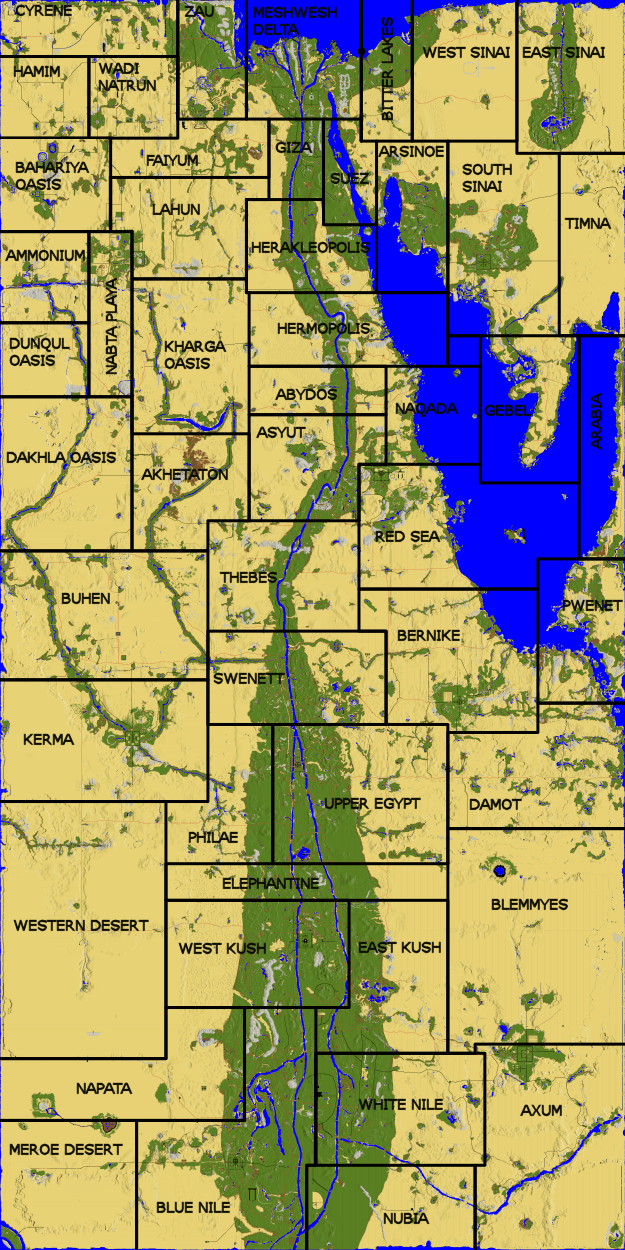
| − | == | + | == T10 Full Map Image == |
[[:File:AtitdFullMap.png]] (20MB) | [[:File:AtitdFullMap.png]] (20MB) | ||
Revision as of 15:53, 6 June 2021
| Resources Legend: |  Limestone Limestone
|
 Sulphurous Water Sulphurous Water
|
 Red Sand Red Sand
|
 White Sand White Sand
|
 Tar Tar
|
T9 Scaled Region Map
T10 Full Map Image
File:AtitdFullMap.png (20MB)
Faction areas
- North: Meshwesh
- Mid: Hyksos
- South: Kush
Regions
- Abydos
- Akhetaton
- Ammonium
- Arabia
- Arsinoe
- Asyut
- Axum (owned by Kush)
- Bahariya Oasis
- Bernike (owned by Hyksos)
- Bitter Lakes
- Blemmyes
- Blue Nile (owned by Kush)
- Buhen
- Cyrene
- Dakhla Oasis
- Damot
- Dunqul Oasis
- East Kush
- East Sinai (owned by Meshwesh)
- Elephantine
- Faiyum
- Gebel
- Giza
- Hamim
- Heraklepolis
- Hermopolis
- Kerma (owned by Kush)
- Kharga Oasis
- Lahun (owned by Meshwesh)
- Meroe Desert
- Meshwesh Delta (owned by Meshwesh)
- Nabta Playa
- Napata
- Naqada
- Nubia
- Philae
- Pwenet
- Red Sea (owned by Hyksos)
- South Sinai (owned by Meshwesh)
- Suez
- Swenett
- Thebes
- Timna
- Upper Egypt (owned by Hyksos)
- Wadi Natrun
- West Kush (owned by Kush)
- Wadi Natrun
- West Sinai
- Western Desert
- White Nile
- Zau
Other Named Areas
- Hinterlands (beyond the edges of the map, and a bit of the Red Sea that has no land)
- Kingdom of Kush (Chariot stop in Meroe Desert)
- Kingdom of Hyksos (Chariot stop in Asyut)
- Meshwesh Tribes (Chariot stop in Meshwesh Delta)
